Discover the rich heritage of Brackenfell and Bracken Nature Reserve. Journey through time, starting with the arrival of the VOC and the implementation of the old cannon signal system. Explore how early farmlands evolved into a bustling suburb, leading to the vital establishment of the nature reserve we cherish today.

On 6 April 1652, Jan van Riebeeck, a commander of the Dutch East India Company (VOC), arrived at the Cape of Good Hope to establish a refreshment station for ships traveling between the Netherlands and Asia. This station, located where Cape Town now stands, provided fresh supplies to passing vessels.
As the settlement grew during the 1600s, it extended inland to support more farming. One such area, known then as De Bottelarij (now part of Brackenfell) served as a key storage site for meat and vegetables that came from local farms. Some of the food were bottled before being delivered to ships docked at the Cape.

The earliest farms in a region where De Bottelarij was situated were Hazendal (1704), Stellenberg (1705) and Kruispad (1712). Brackenfell was developed on the latter two farms.
Stellenberg, originally named Stellenburgh, was granted to VOC official Joan Blesius by Governor Wilhelm Adriaen van der Stel in 1705. The farm was situated next to the Kuils River. Due to the unlawful allocation of land to VOC officials, Van der Stel lost his position as governor of the Cape. Blesius lost his farm and it passed to Jacobus van der Heiden in 1707.

Kruispad, originally named Het Kruijspad, was granted to French Huguenot Josua Cellier in 1712. The farm was situated towards the east of Stellenberg and Cellier named it Kruispad for its location near intersecting roads, like routes from Cape Town to Paarl (Old Paarl Road today) and Tygerberg to Stellenbosch that crossed.
The farm initially consisted of four blocks (A, B, C and D on the map). By 1818, the farm had grown to over 1 000 hectares (map above; the farm was divided into smaller part and sold off in the late 1800s).

In 1862, a railway line from Cape Town to Wellington was opened. The route from Cape Town passed through Bellville, Kuils River and Stellenbosch before continuing on to Wellington.
A section through Brackenfell was added in 1876 when Bellville was connected to Paarl with a shorter route. Though a line crossed the Brackenfell area, a station wasn’t established until 1903 (above).
The railway line eventually reached Beaufort West and in 1885 The line was extended to Kimberley to facilitate the transport of the highly profitable diamond industry.

In 1888, Andries Brink purchased Kruispad farm and sold part of the land that became Kraaifontein. He’s homestead used to be on land that became part of Everite (and was demolished in 1979).
It remained a large livestock farm, situated between four boundaries: Bottelary Road, the Stellenberg farm boundary (which aligns with today’s Brackenfell Boulevard), De Bron Road and the Kraaifontein region.
He found an old VOC signal cannon on Kanonkop hill and was not interested in keeping it so he passed it on to Piet Morkel. Morkel transported it to his farm, Bellevue, where it can still be seen today.
He sold off more parts of his farm, including the largest portion that he sold to George Henry Walton in 1901.

On 23 July 1901, George Henry Walton purchased a section of land on Kruispad farm and named it Bracken Fell. This land later became Protea Heights. Walton purchased a portion of Kruispad to farm vegetables there with his two sons.
Originally from Yorkshire, England, Walton named the farm Bracken Fell. The name reflected vegetation that reminded him of Scotland: bracken is a common fern and fell is the Yorkshire dialect word for hill.
In 1903, Walton sold a section of his land known as Kanonkop to a brick company and a granite quarry was established there.
When the railway station was opened in 1903 it was named Brackenfel after Walton’s farm.

Brackenfell was developed on land originally part of the Stellenberg (1705) and Kruispad (1712) farms. Over time, these farms were divided and sold, forming smaller farms like Ferndale (De Villiers family on Ferndale farm above), Morgenster and Bracken Fell.
The railway station opened in 1903 under the name Brackenfel, thereby giving the surrounding area its new name. During that time, small holdings of nearly 1 hectare were sold for £50 each. Residents made a living through small-scale farming: vegetable gardens, guava orchards, pig farming and dairies. Strict animal-farming regulations in nearby suburbs drove more farmers to settle in Brackenfel.
The suburb of Brackenfel was officially established in 1913, ten years after the railway station bearing the same name opened. Walton fought for the suburb to share the name of his farm (Bracken Fell), but the spelling only changed to Brackenfell and it was still a single word (and the extra ‘l’ was only added to the railway sign in 1946).

In the early years, Brackenfell had very limited municipal support. The nearest officials were based in Stellenbosch, which meant residents had to manage most services on their own: from collecting garbage to building roads. Electricity came gradually: some homes received it in the 1930s, while others waited until the 1950s.
In 1950, the Burgerlike Vereniging was formed, led by John Brink, son of Andries. The group worked to improve local services, build infrastructure and represent the community to the Stellenbosch council. Thanks to their efforts, Brackenfell was declared an independent ward in 1959, with Jurgen Windell as its first council representative.
The 1960s saw rapid growth, aided by access to water from the Wemmershoek Dam. Brackenfell got divided into five wards (central, north, west, south and east) with ongoing improvements to roads (Frans Conradie Drive above), lighting, mail delivery and phone services.

On 1 January 1970, Brackenfell achieved municipal status. For six years, the municipal offices operated from houses in Roslyn Street until a dedicated building opened in 1976. In 1971, Brackenfell’s coat of arms was registered, featuring Kanonkop, three cannonballs, and three bracken fern leaves, symbolizing the area’s landscape and history. The Latin motto "Tenax in fide" means persistent and trusting.
With municipal status, infrastructure rapidly improved: roads were tarred, two railway bridges were built over the railway line, garbage removal and sewerage systems were implemented and services like the high school, library, police and fire station opened.
In 1996, Brackenfell joined with Kuils River and Kraaifontein to form the Oostenberg Municipality. Later, on 5 December 2000, it became part of the City of Cape Town when all Cape Town suburbs were merged into one municipality.
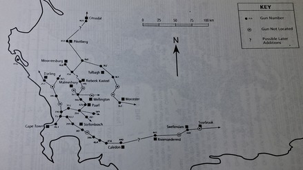
In the early days of settlement at the Cape, signal cannons were introduced on hills as a warning system. They were fired whenever enemy ships were spotted near the Cape harbour, alerting local burghers to prepare for military service. The system was introduced in 1687 with 1 gun at Rustenburg farm (lower slope of Tygerberg). As settlers began moving inland, the system had to be expanded to reach those farther from the coast and steadily increased to 20 cannons by 1734. To improve the system, amount of cannons were increased to 54 during 1758 and 1759 (signal system above).
The signal system was activated four times for military purposes:

In 1759, a signal cannon was placed on Duyvenheuwel (the hill on which the Bracken Nature Reserve is located and where the cannon above can be seen). All cannons, except the 12-pounder placed on Tygerberg hill, were 6- or 8-pounders. The Duyvenheuwel cannon, along with more than 50 others, was fired twice in 1781.
The cannons were regularly inspected and by 1790 the original cannon on Duyvenheuwel was found to be rusted and was replaced.
The new cannon was fired in 1795 and for the last time in 1806. The signal system was discontinued after the British took control of the Cape in 1806, following the Battle of Blaauwberg.

In the early 1800s, Duyvenheuwel was given a new name, Kanonkop, since it used to have a cannon that was part of the VOC signal system.
Kanonkop became part of the Kruispad farm in 1818 when that farm was enlarged to over a 1 000 hectares.
The original cannon placed on Duyvenheuwel has never been found. The replacement cannon of 1790 was found on the side of the hill in 1888 by the owner of Kruispad farm, Andries Brink. Brink, uninterested in the cannon, gave it to Piet Morkel, who took it to his farm, Bellevue, where it remains on display today (cannon above).

Granite were extracted from Kanonkop in the 1800s and was used to make millstones. A millstone can be seen at Brackenfell Primary school today.
In 1903, Walton sold part of his land called Kanonkop to Granite Brick Co. Ltd. A granite quarry opened there, supplying stone for road construction across the Cape.
Granite was transported in containers via a railway from the quarry down to a crusher, where it was broken into smaller pieces for use in construction.
A stone building (above), likely constructed in the early 1900s for workers' quarters, still stands near the entrance of the reserve and is now a national monument.
The quarry closed in 1948, leaving a large hole that was later used as a landfill site starting in 1970.

Despite the large hole becoming storage for garbage in the 70s, the hill retained patches of indigenous Renosterveld and Fynbos, prompting residents to advocate for its protection. Their efforts succeeded and that area was declared a 36-hectare Local Authority Nature Reserve on 16 June 1978.
The Burgerlike Vereniging managed it back then. Their efforts to return the historical cannon from Bellevue farm were unfortunately unsuccessful.
Improvements began in the 1990s, including fencing and the establishment of the first environmental management plan in 2002. This plan proposed a variety of trails, informative and directional signage, a Friends of Bracken Nature Reserve group, closure of the landfill site and reintroduction of a cannon.

The councillor of Brackenfell, Marian Nieuwoudt, recommended that Bracken Nature Reserve started a Friends group to assist reserve staff with management of the nature reserve. On 6 March 2006, the Friends of Bracken Nature Reserve group was founded, chaired by Thea Weyers.
Just as they do today, they hosted environmental talks, led guided walks and assisted with the removal of invasive species. Their inaugural spring event was an Arbor Week celebration, during which they invited school groups to plant trees with them in the reserve.
With donated funds from Rowland & Leta Hill Trust and City Council, they installed benches on lookout points, bought tables and chairs for the prefab environmental centre, established an indigenous garden at the entrance and created brochures about the reserve's history and biodiversity.

The site for the disposal of waste material closed on 2 January 2007 after reaching carrying capacity. The landfill was open for more than 30 years and received roughly 400 tons of garbage every day. It was covered with adjacent soil so that indigenous vegetation can eventually overgrow that area.
As waste decomposes underground, gases such as methane and carbon dioxide accumulates. For that reason, vents (known as whirly birds) had to be installed to safely release those gasses. Leachate (rainwater that mixes with underground waste) must be continuously pumped into a drainage system.
The site is currently undergoing rehabilitation and remains overgrown with invasive weeds and grasses. Due to the release of dangerous gasses, people are not permitted to enter that area. It is managed by the department of Water and Sanitation.

Conservation efforts expanded in the 2010s. A biodiversity survey by CREW revealed almost 300 plant species in the reserve. A grysbok was introduced and the critically endangered Kraaifontein Spiderhead (Serruria furcellata) was planted. As that plant is endemic to only Bracken and a single other location in Northpine, the nature reserve plays a vital role in safeguarding it.
In 2013, a signal cannon donated by Tygerberg Nature Reserve was installed by Neville Smith, who built a stand for it and maintained it for many years. The cannon fired during the Spring Day celebration of 2013, reviving the VOC-era tradition. This has since become an annual highlight.
The old fire station (above) that used to be close to the landfill site was demolished in 2016 due to structural concerns.

The Friends of Bracken continues to assist in the ongoing conservation and management of the reserve. Current needs include pathway maintenance, removal of alien weeds and planting of indigenous flora. There are also plans underway to install new benches.
We are also focused on offering exciting annual events to encourage more people to visit the nature reserve. These popular events include a fun run, full moon hikes and environmental walk-and-talk sessions.
New facilities (including an environmental education centre, offices and a parking lot) are planned for completion in 2026, enhancing the reserve's role in community education and conservation.
Plans are underway for an ecological corridor linking the Bracken and Perdekop Nature Reserves. This will allow the free movement of animals and to provide public access between the two reserves.